East River
| East River | |
| Tidal strait | |
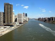
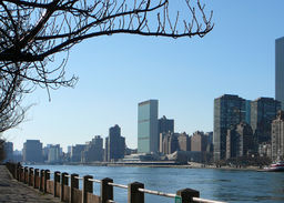 East River and the UN on Manhattan, seen from Roosevelt Island
|
|
| Country | United States |
|---|---|
| State | New York |
| Municipality | New York City |
| Tributaries | |
| - left | Newtown Creek, Flushing River |
| - right | Westchester Creek, Bronx River, Bronx Kill, Harlem River |
| Source | Long Island Sound |
| - coordinates | |
| Mouth | Upper New York Bay |
| - coordinates | |
| Length | 16 mi (26 km) |
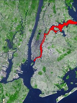 The East River is shown in red on this satellite photo of New York City.
|
|
| Wikimedia Commons: East River | |
The East River is a tidal strait in New York City. It connects Upper New York Bay on its south end to Long Island Sound on its north end. It separates Long Island (including the boroughs of Queens and Brooklyn) from the island of Manhattan and the Bronx on the North American mainland. In reference to its connection to Long Island Sound, it was once also known as the Sound River.[1]
Contents |
History
The river was formed approximately 11,000 years ago at the end of the Wisconsin glaciation.[2] The distinct change in the shape of the river channel between the lower and upper portions is evidence of this glacial activity. The upper portion (from Long Island Sound to Hell Gate), running largely perpendicular to the glacial motion, is wide, meandering, and has deep narrow bays on both banks, scoured out by the glacier's movement. The lower portion (from Hell Gate to New York Bay) runs north-south, parallel to the glacial motion. It is much narrower, with straight banks. The bays that exist (or existed before being filled in by human activity), are largely wide and shallow.
Channel
The East River is dangerous to people who fall in or attempt to swim in it, although as of mid-2007 the water was cleaner than it had been in decades. Anyone in the channel would find there are few places to climb out. According to the marine sciences section of the city Department of Environmental Protection, the channel is swift, with water moving as fast as four knots (just as it does in the Hudson River on the other side of Manhattan). That speed can push casual swimmers out to sea. A few people drown in the rivers around New York City each year.[3] The strength of the current foiled an effort in 2007 to tap it for hydroelectricity.[4]
Historically, the lower portion of the river (separating Manhattan from Brooklyn) was one of the busiest and most important channels in the world, particularly during the first three centuries of New York City's history. The Brooklyn Bridge, opened in 1883, was the first bridge to span the river, replacing frequent ferry service. Some passenger ferry service remains between Queens and Manhattan.
The Bronx River drains into the East River in the northern section of the strait.
North of Wards Island, it is joined by the Bronx Kill. Along the east of Wards Island, at approximately the strait's midpoint, it narrows into a channel called Hell Gate, which is spanned by both the Triborough Bridge, and the Hell Gate Bridge. On the south side of Wards Island, it is joined by the Harlem River.
Newtown Creek on Long Island drains into the East River, forming part of the boundary between Queens and Brooklyn.
The East River contains a number of islands, including:
- Upper section
- Rikers Island
- North Brother Island
- South Brother Island
- Mill Rock
- Lower Section
- Wards Island and Randall's Island (joined by landfill)
- Roosevelt Island
- U Thant Island (Belmont Island)
Crossings
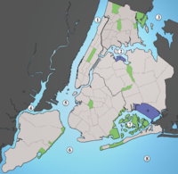
New York City waterways: 1. Hudson River, 2. East River, 3. Long Island Sound, 4. Newark Bay, 5. Upper New York Bay, 6. Lower New York Bay, 7. Jamaica Bay, 8. Atlantic Ocean
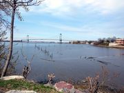
East River flows past Upper East Side
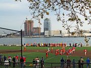
East River passes children playing football in East River Park
Powell's Cove, Whitestone
|
Bridges
The river is spanned by eight bridges, which from north to south are:
- Throgs Neck Bridge
- Bronx-Whitestone Bridge
- Rikers Island Bridge (From Queens to Rikers Island only)
- Hell Gate Bridge
- Robert F. Kennedy Bridge (East River Suspension Span)
- Roosevelt Island Bridge (east channel only)
- Queensboro Bridge
- Williamsburg Bridge (Vehicular traffic & Trains of the J M Z subway services)
- Manhattan Bridge (Vehicular traffic & Trains of the B D N Q subway services)
- Brooklyn Bridge
Tunnels
The river is spanned by thirteen tunnels. From north to south, along with uses as of July 2006:
- 63rd Street Tunnel (Trains of the F subway service - upper level; lower level - under construction and unused)
- 60th Street Tunnel (Trains of the N Q R subway services)
- 53rd Street Tunnel (Trains of the E M subway services)
- Steinway Tunnel (Trains of the 7 <7> subway services)
- Queens-Midtown Tunnel (Vehicular traffic of Interstate 495)
- East River Tunnels (Long Island Rail Road and Amtrak trains from Penn Station to points north and east)
- 14th Street Tunnel (Trains of the L subway service)
- Rutgers Street Tunnel (Trains of the F subway service)
- Cranberry Street Tunnel (Trains of the A C subway services)
- Clark Street Tunnel (Trains of the 2 3 subway services)
- Montague Street Tunnel (Trains of the N R subway services)
- Joralemon Street Tunnel (Trains of the 4 5 subway services)
- Brooklyn-Battery Tunnel (Vehicular traffic of Interstate 478)
Trams
- Roosevelt Island Tramway (west channel only)
See also
- List of New York rivers
- Lists of crossings of the East River
- Geography and environment of New York City
- Geography of New York Harbor
References
- ↑ Montrésor, John (1766). A plan of the city of New-York & its environs. London.
- ↑ The Queens Gazette: The East River Flows From Prehistoric Times To Today
- ↑ [1]"Welcome, Students. Now Watch It.", no byline, article in The New York Times, "Metro Section", August 30, 2007, accessed same day
- ↑ [2]"East River Turbines Face Upstream Battle" Gothamist
External links
- East River NYC from the Greater Astoria Historical Society
- LIC Community Boathouse site for free paddling on the East River
- Hydropower turbines destroyed by East River current
- Western Queens waterfront information page